True north compass: how to point at the real north, not just magnetic north
A true north compass shows the direction to the geographic North Pole, which is the north used on maps, instead of magnetic north, where a needle points. The difference is the magnetic declination for your location; add an east declination to a magnetic bearing (or subtract a west one) and you get the true bearing.
Updated:
What is the difference between true north and magnetic north?
True north is the direction along a meridian towards the geographic North Pole. Magnetic north is where the horizontal part of the Earth’s magnetic field points, and that is what a needle, or a phone’s magnetometer, measures. The angle between the two is called magnetic declination (or variation). It is positive when magnetic north lies east of true north and negative when it lies west.
Declination depends on where you are and drifts slowly year by year, because the Earth’s field changes. Across the contiguous United States it spans roughly from about 15° east in the Pacific Northwest to about 15° west in Maine, while much of central Europe currently sits at a few degrees east. The World Magnetic Model, updated every five years with the current release WMM2025, provides these values for navigation systems and phones.
How do I find the magnetic declination at my location?
The simplest way is NOAA’s online magnetic field calculator: enter your position and date and it returns the declination from the World Magnetic Model. Many topographic maps also print the declination in the margin, but check the year it refers to, since the value drifts. Phone compass apps can calculate it on the device from your GPS position.
- Get your position from GPS or the map.
- Look up the declination for that position and today’s date.
- Note the direction: east (positive) or west (negative).
- Write it on your map or set it in your compass, so you do not have to calculate in the field.
How do you convert a magnetic bearing to true north?
With an east declination, true bearing = magnetic bearing + declination. With a west declination, true bearing = magnetic bearing − declination. Going the other way, from a map (true) bearing to what you dial on the compass, you reverse the sign. A popular memory aid for that direction is “east is least, west is best”: subtract east, add west.
Example with 10° east declination: the needle-based bearing to a summit reads 75° magnetic, so the true bearing is 85°. If you take 85° off the map instead, set 75° on a plain magnetic compass. Small errors add up over distance, as the table shows.
| Error | Offset after 1 km | Offset after 1 mile |
|---|---|---|
| 2° | about 35 m | about 56 m (185 ft) |
| 4° | about 70 m | about 113 m (370 ft) |
| 6° | about 105 m | about 169 m (555 ft) |
What is grid north, and does it matter?
Topographic maps often carry a coordinate grid, such as UTM or MGRS. Its vertical lines point to grid north, which matches true north only along the central meridian of each 6° UTM zone. Towards the zone edges the gap (grid convergence) grows to a few degrees in mid latitudes. For most hiking it is small, but for long legs or precise work check the angle printed on the map.
Why is my phone compass wrong, and how can I check it?
A phone’s magnetometer is easily disturbed: magnetic cases and mounts, a car body, steel railings, rebar in concrete and other electronics all bend the field the sensor sees. A typical sign is a field strength that differs clearly from what the Earth produces at your location, which is roughly 25 to 65 microtesla depending on where you are on the globe.
You can verify direction without the magnetometer. The sun’s direction (azimuth) for any place and time can be calculated, so a shadow is a natural reference: a shadow always points directly away from the sun. Around local solar noon in mid northern latitudes the sun stands due south, so a vertical stick’s shadow points close to true north.
- Remove magnetic cases and step a few metres away from cars and metal before you read the compass.
- Recalibrate by moving the phone slowly in a figure eight.
- Hold the phone flat for a horizontal bearing.
- Never look directly at the sun when checking direction.

How Solnord works as a true north compass
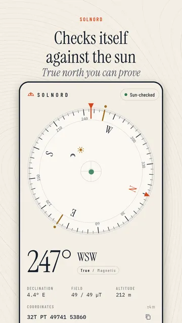
Solnord is a compass for Android that applies the magnetic declination for your location from the World Magnetic Model, calculated on the device, and switches between true and magnetic north with one tap. It tells you when the magnetic field around the phone looks disturbed and lets you check the compass against the sun or the moon.
- True north and magnetic north, with the declination shown in degrees.
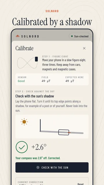
- Sun check: lay the phone flat along a shadow and tap once; Solnord calculates the sun’s position for your place and time and corrects the compass. At night it uses the moon.
- Magnetic interference warning with live field strength compared with the value expected at your location.
- Calibration guide, bubble level and upright mode that shows the direction of the camera.
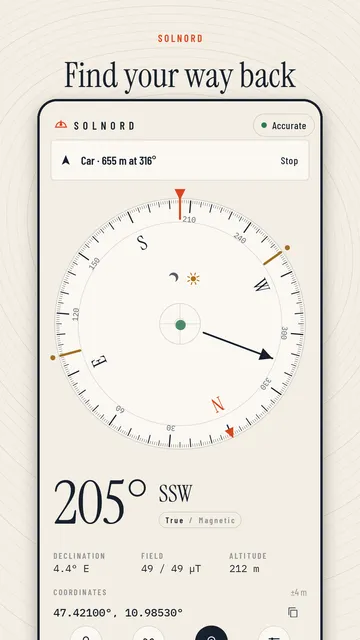
- GPS coordinates with accuracy, a bearing lock and one saved place with the way back; altitude above sea level on Android 14 and newer.
- Pro: unlimited places, sunrise and sunset directions, off-course alert, DMS, UTM and MGRS coordinates, and a red night light.
What the app cannot do
Solnord needs a phone with a magnetic sensor and is only as accurate as that sensor and the GPS; it cannot remove interference, only warn about it. The sun check needs a visible shadow, and the app has no map view.
Price
The compass, sun check, bearing lock and decimal coordinates are free; Pro costs $1.99 a week or $9.49 a year in the US through Google Play, and you can cancel anytime. The free version shows ads; Pro is ad-free. We build this app ourselves; on Google Play it is listed under the developer name InfinityAkhi.
Get it on Google Play: Solnord
Screenshots
Related calculators on ToolboxDay
Frequently asked questions
Does a true north compass need the internet?
Not necessarily. The World Magnetic Model is built into Android, so an app can calculate declination on the device from your GPS position without a data connection.
Is declination the same everywhere?
No. It depends on your location and changes slowly over time, which is why maps state the year their declination value refers to.
Why does my compass point differently near my car?
Steel and magnets bend the local magnetic field. Step a few metres away, remove magnetic cases and check whether the measured field strength matches the expected value.
What does “east is least, west is best” mean?
It is a memory aid for converting a true (map) bearing to a magnetic one: subtract an east declination, add a west declination. For magnetic to true, do the opposite.
Sources
More guides
- EMF reader on your phone: how to measure magnetic fields and read the numbers
- Live moon wallpaper: moon phases, moonrise and battery explained
- KP index explained: what Kp you need to see the northern lights
- Recurring payments: find them, add them up, cancel what you don’t use
- Lean angle motorcycle guide: how it is measured and what the number means
- Constellation finder: how to find constellations in the night sky
- Our apps